Be the First One on Your Block to Instigate a Missile Crisis (No, really.)
Update: Scroll down and tell me I didn’t find what I think I found.
Yes, I had spent many hours “flying” over North Korea with Google Earth, but it took this article to tip me off to an entire online community of amateur photo intel analysts. The L.A. Times reports:
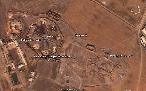
An intrepid German poster named “wonders” has flagged more than 332 sites of interest. Most are military — the vast air defenses ringing Pyongyang, the artillery along the demilitarized zone, the Yongbyon nuclear facilities, tunnels, caves and weird earthworks. He’s labeled a gigantic buried half-cylinder as “Underground parking garage — not!” and an ominous-looking lump as a “Not too friendly looking thing.”
[….]
Of course we know the ugly facts about North Korea — in the abstract: That it’s one of the poorest, most highly militarized nations in the world, with a malnourished population and a thirst for nukes. That it sends children of the disloyal to be worked to death in camps. That visible earthworks are most likely telltale signs of vast underground cities it has dug to hide its military facilities from Western spy satellites.
But we haven’t been able to see it for ourselves. Now Korean War veterans in Peoria or cyber geeks in Hong Kong can peer down upon the repressive state from their living rooms, for kicks.
Enjoy, and please feel free to check back in here with any interesting finds. Since members of the intel community read this site, I’m quite happy to make their work easier.
Update: OK, found plenty of AAA sites and fighting positions. I suppose you can find plenty of the same around Uijongbu in the South. But now, have a look at this and tell me I’m off-base. The site is a mountaintop overlooking the Taedong River, about 10 miles due east of Pyongyang. The area is surrounded with anti-aircraft sites, but otherwise, few houses and no farming or other activity of apparent economic value is going on there. The roads leading in are really just trails.
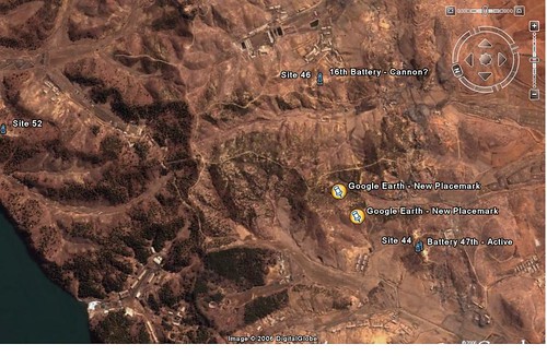
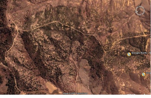
A closer view. It’s a large area filled with roundish blotches of freshly-turned earth.
Korean bury their dead in round graves on hilltops, preferably overlooking scenic places. I’m obviously an amateur about this, but the only conclusion I can draw is that this is a huge improvised cemetery (coordinates = 39 deg., 2 min., 24 sec. N, 125 deg., 55 min., 44 sec. E). I realize that we tend to see things according to our predispositions, which is why I’m inviting everyone to tell me what else this could plausibly be.
Even closer in, and just off the southern edge of the previous photo.
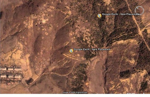
Closer in yet. Now, take a look at that prominent gash — the one nearest the houses, along the in-bound road access. Could this be the kind of mass burial site that Andrew Natsios described witnessing?
Obviously, I have no idea what these people died of, nor can I really be certain that these are graves. If they are, it’s telling how poorly tended and numerous they are. Those who buried them almost seem to have scooped out holes in the ground wherever space was available. How sad.
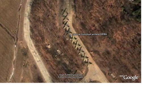
Update 2: Nine SU-25 “Frogfoot” ground attack aircraft, sitting unhangared on the edge of the tarmac at Sunchon Airfield, North of Pyongyang (39d24’47” N, 125d53’53” E). This certainly doesn’t suggest top-quality maintenance.
—–
Weird – the border lines are drawn to make Panmunjom in North Korea.
The border with Russia is off, too.